
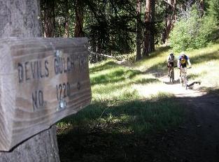
Devils Gulch Trail No. 1220
Wenatchee, Cashmere, Chelan County Washington USA
|
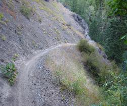
~~ Devils Gulch Trail Description: The Devils Gulch is known as one of Washington State`s classic bike rides. Devils Gulch lives up to the hype in many respects. Some cyclists, loathe to pedal the 12-mile, 3,300-foot climb that starts this loop, shuttle a car to the trail head and begin riding from the top. To give you an idea of how continuous and unabated the descent is, some BMX riders can complete a one way trip from the top on a one speed BMX bike. Also, strong riders have been known to ride up Devils Gulch trail and walk up the switch backs, and then ride down the trail. The Devils Gulch trail is not a throw you over the handle bars, every man for himself kind of trail, but because parts of the trail skirt along the edge of drop offs, this trail is probably best left to the advanced bike riders. ~~ Devils Gulch Trail Directions And Information: From Wenatchee, go up Squilchuck Road toward Mission Ridge. Follow the Squilchuck Road one mile past Squilchuck State Park and turn right on Liberty Beehive Road 9712. Go up this road about 4.3 miles to the Devils Gulch Upper Trailhead. The Devils Gulch Trail No. 1220 Access, begin from the trail head at the Beehive Reservoir on Liberty Beehive Road 9712. head off down to Mission Creek Road No. 7100. BMX & Mountain Bikers generally like to be dropped off above the Beehive Reservoir to begin at the Beehive Devils Gulch trail head and travel the route down to Mission Creek. 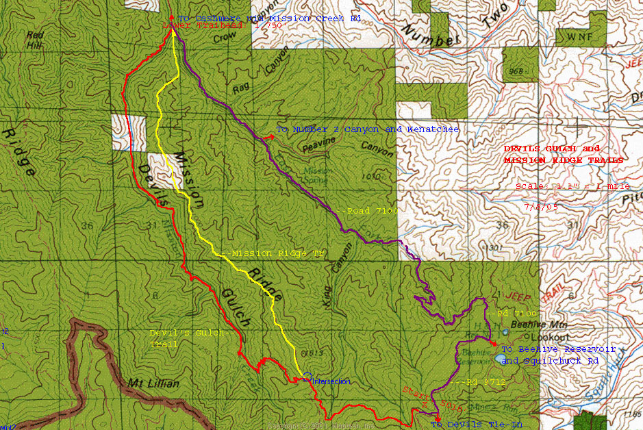 ( Click On Photo [ Map ] To View Full Size ) Locator Map - Length 12.3 miles one way. Several adjacent trails offer longer riding opportunities: ten-mile Mission Ridge No.1201 three-mile Red Hill Spur No.1223.1 eight-mile Red Hill No.1223 three-mile Devils-Mission Tie No.1204 Allowed BMX & Mountain Biking, Hiking, Trail bike riding, Horseback riding. Bikers and Hikers may encounter each other on blind corners. BMX & Mountain bikes are fairly quiet and gain speed coming downhill. Not allowed Three or four wheeled ATVs. Elevation Gain: Devils Gulch has a moderate grade, however, adjacent trails offer access to steeper terrain and provide more challenging trail bike and bmx & mountain bike riding. What you will see From Mission Creek, beautiful sandstone spires and rock outcroppings, all part of the Swauk sandstone formation. Lower portion wanders for quite a distance through a riparian area filled with large cottonwoods and poplars.Streamside segment offers great places for bird watching among the hardwoods. Look for occasional beaver activity, along with signs of bears and coyotes. Ascending toward Mission Ridge, travelers step out of the riparian area and into an open ponderosa pine forest of large trees with a parklike feel. Up toward Liberty Beehive Road awaits a denser north-side forest moister, cooler, shaded. Breaking into the open at the Liberty Beehive trail head, visitors are rewarded by a nice view of Mount Stuart and Glacier Peak. Information: Leavenworth Ranger District 600 Sherbourne, Leavenworth, Wa 98826 (509) 548-6977 - Wenatchee National Forest * http://www.fs.fed.us/r6/wenatchee * http://www.fs.fed.us/r6/wenatchee/recreation/bike Other Information Sources: Devils Gulch: * http://www.visitcashmere.com/mountainbiking.html * http://www.leavenworth.org/modules/pages/pageid=224&path=7 * http://www.mbronline.com/mbr_html/wa/wa_trail/dv_gulch.htm * http://www.dirtworld.com/trails/trail.DevilGulchMountainBikeTrail * http://content.mtbr.com/Trails/Washington/Devils Gulch * http://www.trailsgalore.com/trails/Devils_Gulch_Trail_Washington.html * http://www.activetrails.com/trail.cfm/1078/Devils-Gulch Wenatchee |
|---|
|
~~ PIPELINE TRAIL ~~ Take the Beehive Reservoir road pass the reservoir to the large Devil's Gulch Trail parking area on the right; across the road is a wide single-track trail. Although this trail is most often used as a connector for loops with other trails such as Devil's Gulch, Devil's Spur, Lake Clara, or the Mission Ridge Trail, the Pipeline can be a suitable training route for someone new to single -track riding because the feeling of exposure is fairly minimal and it's fairly flat. It's an out-and-back; when you get to Chair One at Mission Ridge, just turn around and head back. Total elevation gain: virtually non. Length: about six miles round trip. You can make it a slightly tougher ride by doing to from the other direction, starting the the Mission Ridge parking lot, going up the service road, then out and back. ~~ DEVILS SPUR ~~ On the drive up to Mission Ridge, park in the small parking area alongside the last hairpin switchback on the left, where there's a big rock outcropping and view spot on the right. The trailhead is there, and it;s a gradual climb to Devil's Gulch Trail. Most people go to Devil's Gulch Trail, hang a left across the parking lot to the Pipeline Trail, following that to the Mission Ridge Service Road next to Chair One, then following that back down. Total elevation grain: about 400 feet. length: an eight-mile loop. For Other Information RE: Devils Gulch Trail Alternatives: * Just Get Out.net/Wenatchee/Devils Gulch Alternatives * Just Get Out.net/Wenatchee/Guide Book: Mountain Biking |
|---|
___________________________________________________________________
A Fun Long Devils Gulch BMX Ride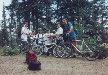 Photo by Gene`s BMX August, 1995 A group of BMXers and Bikers ride 12 mile Devils Gulch trail. For a BMXer the best spot to start off to ride Devils Gulch, would be at the Mission Ridge Lodge Parking lot. You start off about 1/2 of a mile of uphill to the pipeline trail. Then go Northwest for about 3 miles on the pipeline trail. Pipeline trail is mostley a flat trail to ride on. "Once you battle the 1/2 mile of uphill at the start". Pipeline trail will end at the trail head of Devils Gulch trail, on the Liberty Beehive Road, "just go across the road". Devils Gulch trail this way is all most all down hill for 12 miles. Lots of nice small dirt and rock jumps along with a hand full of mud holes and creek crossings.Once you battle all the 12 miles of down hill and some flat parts of the trail, you end up at Mission Creek Trail head of the Gulch. The Bottom, From ther you can have a car parked and drive back home or, you can ride Mission Creek Road down in to Cashmere. The dirt gravle road gos downhill for about 2 1/2 miles till you get to the paved road. On the paved road its 6 miles in to Cashmere, of some small hills weevy paved road."allmost all down hill" Mission Creek Road ends with you facing a School house building in Cashmere. This trip of the Devils Gulch ends you at a 24 mile ride. The best time of day to start off is about 8am Make a day group ride of it, Pack a lunch, Have FUN and be Safe! Happy Riding! |
|---|
___________________________________________________________________
|
Click On A Photo To View Full Size! 


______________________________________________________________  www.flickr.com/photos/igor_r/sets/72157602162139139 MTB Devils Gulch 08/24/2007 Photos Page by Igor R. * http://www.youtube.com/watch?v=2adb6TKgaD0 * http://www.youtube.com/watch?v=g41DQIAbNVQ * http://www.youtube.com/watch?v=ET1nSY-TPvA ______________________________________________________________ Geneb...Wenatchee,Washington-USA All Things Northwest in BMX! ***** Gene`s BMX ***** http://www.genesbmx.com |
|---|